Welcome to JC White Geomatics
JC White Geomatics are surveyors in Kent with an unrivalled reputation amongst developers, architects, engineers and both central and local government departments. A reputation built on over 30 years’ experience providing cost-effective, efficient and accurate solutions to any land survey project.
We use our exhaustive quality procedures to ensure client requirements are fulfilled and that any survey plans produced are to a high cartographic standard. With our extensive professional knowledge we can advise and perform all land surveys related to a project.
Why JC White Geomatics:
+ Free consultation
+ Free advice
+ Free estimate
+ Well respected
+ High level of repeat business
+ High cartographic standard
+ Experienced, highly qualified staff
+ Information rich drawings
+ High quality product
+ Expert personalised advice
+ Each project individually assessed
Dave Johnson, Eurotunnel
'We have worked with J C White for over 16 years and have found them to be professional and a very favourable company who complete al work in a timely fashion.'
Sam Jarvis, Jarvis Homes
'We have worked with J C White for over 30 years and use them exclusively on all our developments. We have constantly found them to be a professional, efficient and cost-effective company that adds value to our projects.'
CMS Enviro
'J C White is a proficient, professional, relaxed and approachable company.'
Mr & Mrs D Crawley
'My wife and I are very pleased with the survey work that you carried out and our solicitor assures us that on the evidence of your survey, our position is secure for the future. We would like to thank your two young men who carried out the survey for their polite good manners, helpful attitude and professional workmanship.'
Mr Richard A Maltby, Director Maltby Land Surveys Ltd
'I would like to say that JC White Geomatics are relatively local to us and we have come across their work over the years which has always been of a very high standard. I have interviewed a couple of their staff for membership into the ICES and have found them a credit to the profession. The company seems to have a very contented workforce with the management investing heavily into training.'
Dean Bain, Survey Manager Costain
‘We have been working closely with J C White Geomatics for some 6 or 7 years now. They have proved to be accurate, honest, trustworthy and innovative. They also do what they say they will do. They are my first port of call for a wide range of external survey work.’
Mike Guntripp
Director

BTEC Higher Diploma in Land, Sea, Engineering Surveying and Mapping
Mike is at the very hub of the business and ensures smooth running of the day to day business supervising 20 staff. He joined in 1994 and has over 25 years’ experience as a qualified Land Surveyor, initially as a Field Surveyor working both in the UK and overseas in Peru and Pakistan.Mike liaises with clients to determine scope of works required and advice on specification requirements. He is also our QA guru and is involved directly with company strategy and planning.
Andy Kay
Director

HNC Surveying and Land Information
Andy first joined J C White Geomatics in 1998 for 9 years, during which time he trained at Lambeth College and we were very pleased when he rejoined us in 2011. He is now our Engineering Survey and Setting Out specialist and also works on monitoring projects.
JC White Geomatics latest news:
Thank You
To say 2020 has been a difficult year would be an understatement. Back in March we had to completely re-think the way we work, principally on site but also in the office and from our own homes, and, like most businesses, we faced a great deal of uncertainty with jobs...
Mobile Scanning, the CAA and our new recruit
Two of our surveyors have recently undertaken a 4-day mobile scanning course enabling them to capture, process and utilise data from laser scanning technology on the move. This expertise enabled us to use a combination of vehicle-mounted mobile scanning & UAV...
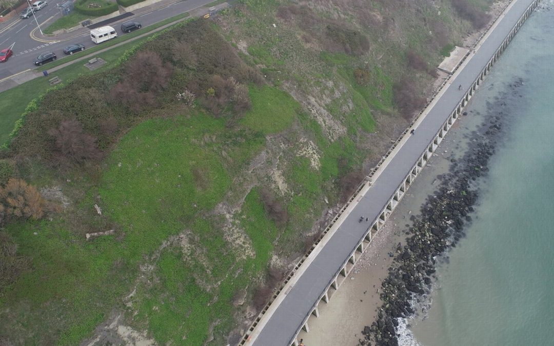
UAV Survey Projects
Our PfCO qualified UAV pilot has been capturing data with our drone for an ever-growing range of projects. Most recently Deep Ocean engaged our drone services to conduct a detailed topographical survey of Pegwell Bay beach two years after the burial of the Nemo cable,...