Two of our surveyors have recently undertaken a 4-day mobile scanning course enabling them to capture, process and utilise data from laser scanning technology on the move. This expertise enabled us to use a combination of vehicle-mounted mobile scanning & UAV photogrammetry for our client A-One+ to produce topographical survey data of Cophall Roundabout in Polegate.
The surveyors first established survey control along the safe publicly accessible areas before a thorough driving plan was devised to ensure that all areas of the roadway were captured. The routes were then driven at normal speed so as to cause no disruption to other road users.
The combination of the mobile scanner’s 3D point cloud and the data from the UAV photogrammetry captured by our CAA qualified drone pilot allowed us to quickly and accurately produce topographical survey information for the full road width of one of the busiest roundabouts in the South East of England without using any road closures or compromising the safety of our staff, equipment, or members of the public.
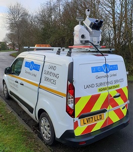
Mobile Scanning Unit mounted on van
We were chosen at random to be audited by the Civil Aviation Authority last week and passed with flying colours. Our record keeping, flight planning, maintenance and safety procedures were all found to be in line with their tough standards.
Finally we have a new recruit, Ben, who has settled in well as a trainee land surveyor and become an integral part of our team over recent months.